.................................. Return to Sumner's Home Page....
Return To Suzuki 200 Main Menu.... Return To Trail Rides Menu
=========================================
...............Previous Page.............................Next Page If There Is One
=========================================
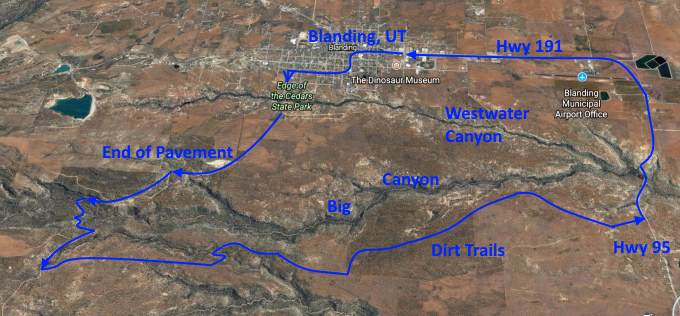
…........--- Sept. 2015 ---West of Big Canyon ---
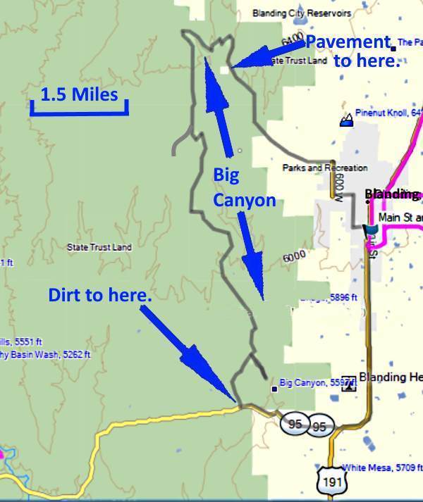
This was a nice ride with a lot of it on the west side of Big Canyon. Big Canyon is the second canyon west of Blanding, only a few miles west of town and our house.
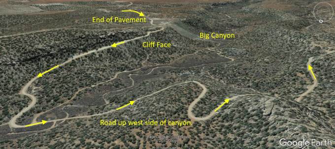
The route was out the northwest side of Blanding on what is called the 'old dump road' as in days past Blanding's city dump was on the rim of Big Canyon. Those days are gone but the road is still there. It is a short ride of pavement from the city limits to Big Canyon where the pavement ends and the county road turns to gravel.
At the end of the pavement the transition to gravel is quite dramatic as you round a sharp turn on the gravel and you see the canyon floor a couple hundred feet below you with no guard rail. I always slow for this as there are two blind turns in a row and the road is just over a lane wide there so you don't want to meet another vehicle coming up the hill in your lane.
When the county road turns to gravel you drop down into and then climb out of Big Canyon. After topping out it is just a short distance to another county road that heads south and eventually meets up with Highway 95. 95 connects to Highway 191 on Blanding's south side. This county road is more dirt and narrower and not well maintained. I followed the dirt road south for a ways, taking a short side detour on a jeep road where …...
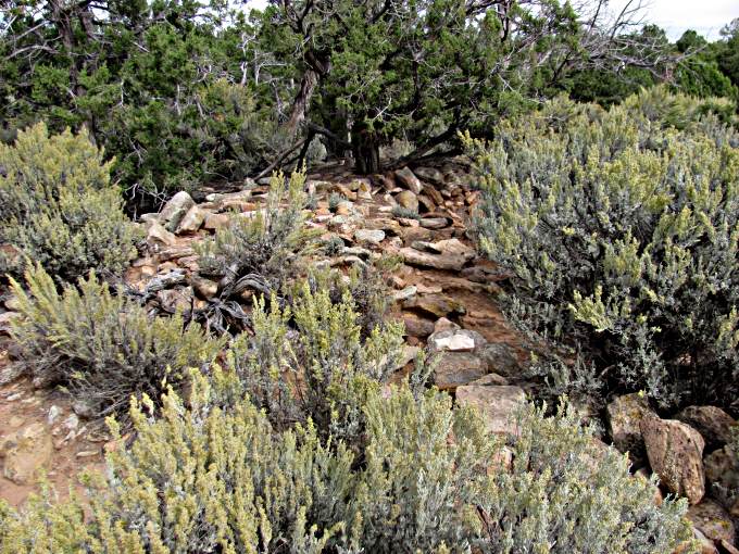
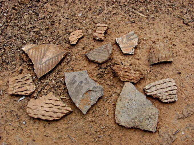
…... I came upon the Anasazi ruin above. This is the remains of probably a Kiva and other structures. A lot of the Anasazi ruin sites are not the well know cliff dwellings but sites like above where multiple people lived or single family sites. The Anasazi left this area by 1300 so all of the sites here are at least that old and many hundred's of years older than that.
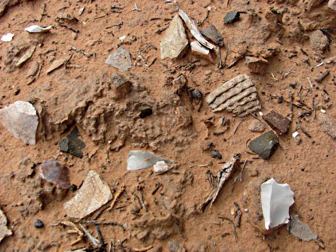
On the ground there were numerous pieces of broken pottery and stone fragments left over from making stone tools.
A previous visitor had made a small pile of larger pieces of pottery in one location. It is recommended that one does not do this. Look , but leave things where they were for the next lucky person that gets to view the site.
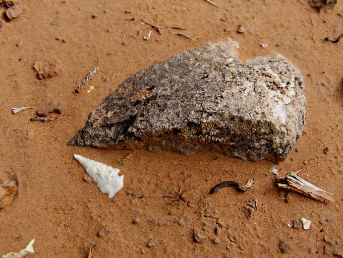
I was lucky enough to be able to see and photograph an arrowhead that hadn't been found and picked up by a previous visitor to the site.
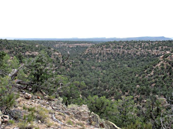
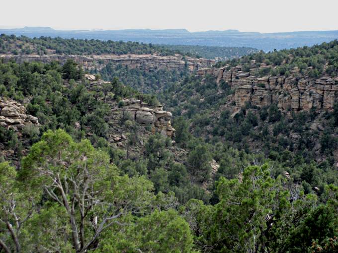
I continued south on the county dirt road for a ways and then headed east on a little used unimproved jeep trail in the direction of the canyon rim. The picture is looking back up canyon towards the north and the road down into and back out of the canyon that I'd taken is out of view at the top of the picture.
Looking across the canyon I could make out a small Anasazi ruin on the far rim and was able to use the telephoto on the camera to bring it a little closer.
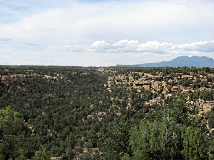
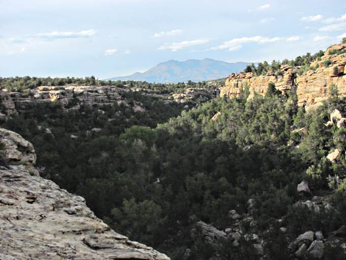
There are a number of trails near the canyon rim and I continued to follow the one closest to the rim and when near the rim would park the bike and walk over. Above we are looking up canyon and can see part of the 11,000 foot Blue Mountains which are about 15 miles north of town.
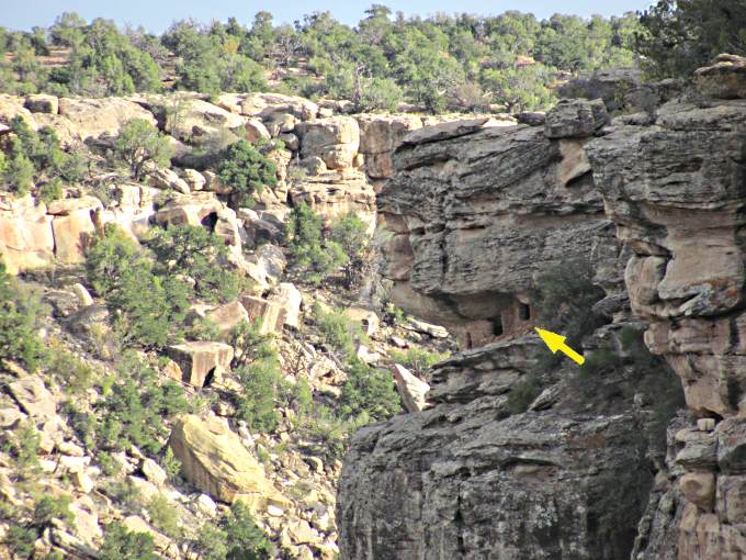
Other cliff dwelling ruin sites came into view as I work my way south along the canyon's rim.
Big Canyon runs south with Westwater Canyon just to the east of it. They meet just above Highway 95 and then form one canyon called Big Westwater Canyon. A little further south Big Westwater dumps into Cottonwood Canyon, which was the site of another ride that you can find ( HERE ) and Cottonwood runs south and empties into the San Juan River at Bluff, UT about 22 miles south of Blanding.
Continuing south on the dirt trail that is an easy ride ….
…. I came across another small ruin that was probably a granary used to store corn or other food stuffs. The doorways to these were usually blocked with a large flat rectangular stone that was plastered in to protect the stored food from rodents and possibly human raiders. Most of the clay stucco that covered these granaries has eroded away over time, but when it was there it would have been very hard to of seen these from a distance. During the year, probably the winter, when food was needed they would come and open the granary and retrieve the contents.
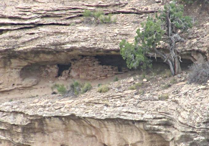
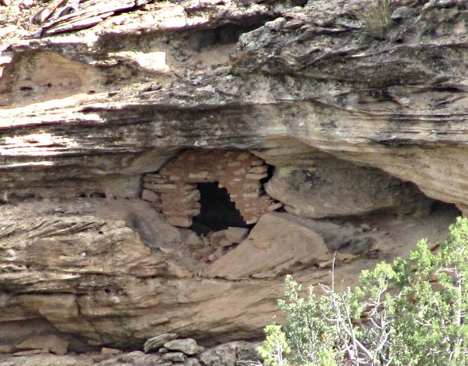
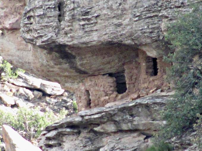
My last little hike to the canyon's edge after parking the bike reviled the high cliff dwelling shown above that was on the same side of the canyon that I was on but definitely in a place that I also wasn't going to get to.
I zoomed the camera in and took the picture above. It is quite amazing were some of these ruins are located. There are others like this withing just a mile from where this was taken. At one time there were far more people living in this region than there are now.
San Juan county is the largest county in Utah and one of the top 25 largest counties in the U.S. Area wise, larger than some eastern states. Yet our population is under 15,000 with a little over 50% of that being Native Americans, mostly Navajo. The county only has one 4 way traffic light and is bordered by more counties than any other county in the U.S. (14). Most of the county is either BLM, Forest Service, State Lands or National Park or National Monument land, with Bears Ears National Monument being entirely within the county.
I took one last look up Big Canyon towards the Blues and then rode a short distance back to the dirt county road, which soon meet up with Highway 95. Took 95 east down into and out of Big Westwater Canon and on to Hwy 191 and back to Blanding.
This was a nice ride, nothing too difficult, with a lot of nice scenery and interesting Anasazi Sites on the way.
=========================================
........................................................Next Page If There Is One