..........MacGregor Index Page.......... 2015 Bahama Trip Index Page
..................Previous Page....................................Next Page If There Is One
=========================================================
....
|
..................--- Upper Matecumbe Key --- ......................................................--- to --- .--- Tarpon Bay -- Key Largo Gulf Side ---
|
|
....................... ..(March 19th) Anchorage --- N 25º 07.219´ ==== Trip Mileage = 296 miles ..................W 80º 25.263´ ==== Day's Mileage = 23 miles |
=========================================================
I needed to get gas, or wanted to if possible and figured I could get it at the marina that is under the highway 1 bridge where it crosses from the Keys to the mainland at Jew Fish Creek but also wouldn't mind getting few other things as I had shopped and packed in a hurry back at the boatyard. I got on the Internet and posted on one of the boards if anyone was in the area of the upper Keys and if they might possibly have time to haul me around to get the stuff I should of already had with me.
I was lucky and Ixneigh (goes by Ix for short on the board) from the Macgregor X/M board responded and asked if I could meet him at Tarpon Bay at Key Largo. They have a city dinghy dock so that removed one obstacle, were I could go ashore, which can be a problem in the Keys. So the plan was to meet him late afternoon.
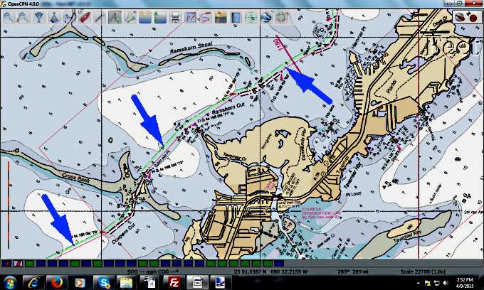
I got on OpenCPN and plotted a course for Tarpon which wasn't hard as you only have one choice and ...
..... that is to follow the twisty ICW that runs here on its way to Key West. Ruth and I had been along it but since I'd already screwed up thinking I'd remember everything from that trip I put the waypoints in OpenCPN and also the Garmin handheld and headed north.
The water was dead flat with absolutely no wind for almost the entire way.
All of the views took on the look of pastel paintings.
Quite pretty actually with a surreal look to it.
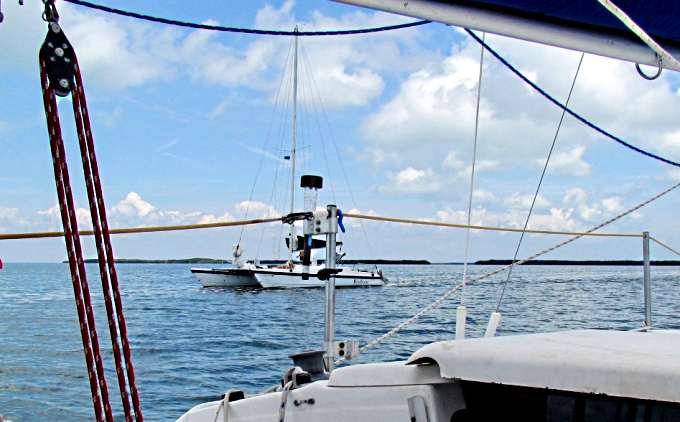
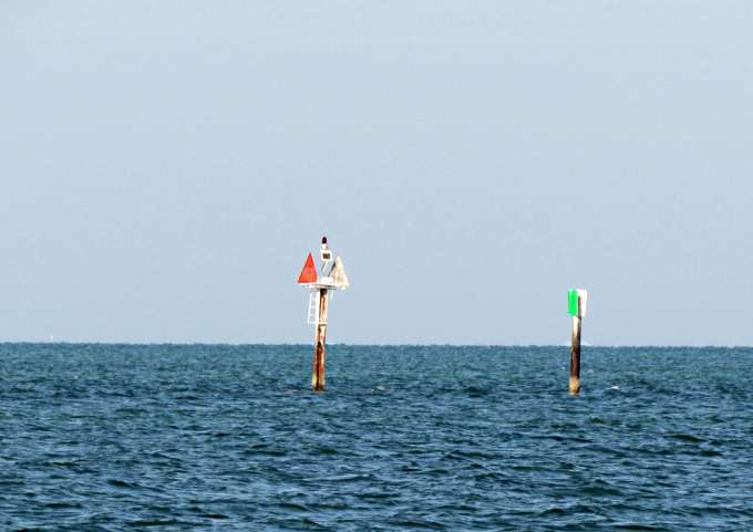
I passed another Macgregor on the way.
A Macgregor ....
....... 36 foot catamaran that MacGregor produced in the 70's-80's.
According to the info at SailBoatData.com it looks like Roger produced about 300 of these very fast cats. I waved, the guy on the cat didn't. Oh well so much for Macgregor solidarity ;-).
I got in and anchored mid afternoon not too far from the city's landing and called Ix and we planned on meeting around 5. He came and picked me up and took me to West Marine where I wanted to buy a spare set of sailing gloves since mine were getting pretty nasty. Huge store but no gloves. Lots of wearing apparel where you could outfit yourself to look pretty cool on a boat. I'm not much into cool, especially at West Marine prices so passed and bought a couple more high priced carabiners as I never seem to have enough. We then filled up my gas containers (12 gallons total) at a gas station that sold marine/non-ethenol gas. That was much easier than stopping with the boat to do it since I still have an aversion to getting on and off docks with the boat. Then it was off to the grocery store. Items are not cheap at Key Largo and I couldn't believe the traffic on Highway 1. 4 lanes of non-stop moving vehicles. Then it was off to a nice little place for dinner. First time I ever ate soup out of a big rounded hunk of bread with its center cut out. It was good so good choice on a place to eat Ix and visit. Then back to the marina where by now it was dark. I dug out my dinghy lights and they actually worked and with Ix's help I had the dinghy loaded and was off to the boat.
I owe a big thanks to Ix for doing this for me and he also gave me a lot of valuable info on the Bahamas and the cuts at the northern end of Key Largo where I would be going out. He has been in the area a long time so had a lot of good info that was a big help to me. He had taken a smaller Macgregor 22 footer to the Bahamas some years before and here I thought I was adventuresome taking a 26 footer. He told me about the trip and I was in awe as I had a lot of things on the boat that he for sure didn't have when he took his boat over and he didn't just go to Bimini but on all the way to the Exumas where I hoped to also go. Thanks again Ix.
=========================================================
|
....................................--- Tarpon Bay --- ......................................................--- to --- ............--- Pumpkin Key -- Card Sound ---
|
|
....................... ..(March 20th) ..Anchorage --- N 25º 19.722´ ==== Trip Mileage = 315 miles ....................W 80º 17.623´ ==== Day's Mileage = 19 miles |
Not real sure why I didn't take any pictures this day but didn't. Ruth and I did part of this leg at the very end of our trip but turned west after Jew Fish at the south end of Barnes Sound and went up and into South Dade Marina where we had previously moved the Suburban and trailer to and took the Mac out at the end of our trip. For a few pictures of that trip click (HERE).
This leg was basically sound to sound. First Blackwater and on the north end of that you enter Jew Fish Creek that takes you under Highway 1 that goes down to Key West. This is where it leaves the Keys and crosses over Jew Fish Creek and lands on the mainland.
Just north of Jew Fish you enter Barnes sound and on its north end you cross in the remaining bridge that connects North Key Largo with the mainland. After the bridge you find yourself in Little Card Sound, which is of course smaller than the other sounds. Leaving it you are now in Card Sound which is just south of Biscayne Bay.
You could move up to Biscayne Bay and No Name Harbor there where many boats wait to make a crossing to Bimini. I didn't want to do that for a few different reasons. One being I think it costs to hang out there, but check for yourself if that is going to be your choice of places to cross from. I felt leaving further south would give me a better angle on the Gulf Stream crossing so chose to look for a way out below there. There are a couple different choices but after reading about them and with help from friends, thanks Bill and Ian, I chose to go out Angelfish Creek which is also the one furtherest to the south. Not sure why any of these are called 'creeks' as none look like the creeks I played in as a child in Missouri.
A popular place to stage to go out Angelfish is Pumpkin Island, which is private, as depending on wind direction you can pick out which side to anchor on. Me, I picked the north side as what wind there was was coming from the south. In fact I'd been able to sail the last miles in here once clear of Little Card Sound on that wind as it came up about there. I had to motor before that on mostly flat water.
So anchored there all I had to do now was sweat going out Angelfish as reading about it and any of these cuts you will read that you can get into trouble in them if you aren't careful or the conditions go to hell.
=========================================================
|
......................--- Pumpkin Key --- .................................--- to --- - Atlantic Side of Upper Key Largo -
|
|
....................... ..(March 21st) ..Anchorage --- N 25º 19.585´ ==== Trip Mileage = 320 miles ....................W 80º 15.262´ ==== Day's Mileage = 5 miles |
=========================================================
Up until this point of the trip I was pretty much in somewhat familiar territory in where I had been and what I was doing. The next couple legs would be all new territory to me both physically and in the nature of what the boat and I would have to accomplish. One would be crossing the Gulf Stream to Bimini but first I needed to get to the Atlantic side of the Keys and quit hiding on the Gulf side. Weather for this day and the next looked about as perfect as I could hope for but that wasn't suppose to hold true for very long. You don't want to cross the Gulf Stream with any north wind as it pushing on the current that is going north is going to make for very uncomfortable conditions and maybe life threatening ones in some situations. I was intent on avoiding those so I was at the moment where either I had to get this done or head someplace else as waiting with the current excellent conditions would be a big mistake.
For the night coming up the winds were suppose to be light out of the south so if I could get over to the Atlantic side of north Key Largo and anchor there in mild conditions even though I'd be exposes I'd then be in a good position to stage and leave.
The problem was getting there and that involved going through one of the 3 cuts which I outlined in the report for the day before this. So if you read that you know I settled on Angelfish. Now when should I go through the cut. You want to do it respecting the current that can be in these cuts, which at times can be over 3 kts. I again drew on some of the resources that OpenCPN has that are built into the program and two that SeaClear didn't have.
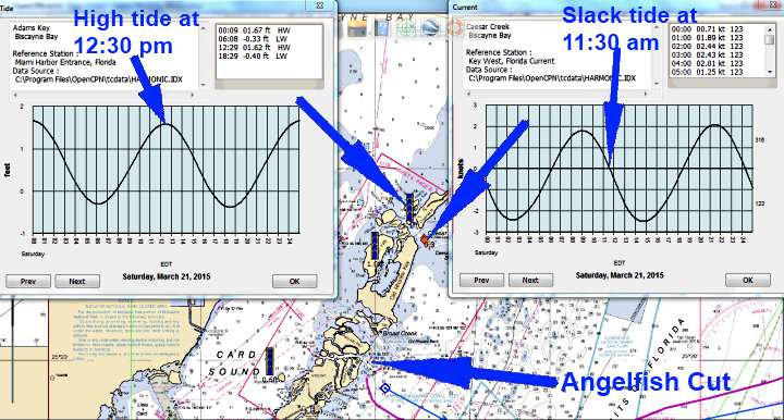
With OpenCPN you can bring forward onto the screen data for tide and current stations if there are any nearby for any day of the year. There wasn't a station for either at Angelfish but there was for Caesar Cut not far to the north (4 ½ miles). Looking at those I could see that high tide was around 12:30 pm and that slack tide with zero current was at about 11:30 am. So if I was smart I'd try and go out around 11:30 am when their would be very little current.
I wasn't far from the cut so it wouldn't take long to run over there so thought I'd try and calibrate the tiller-pilot since I had never done that. It involved running the boat in slow circles and a few other things. I pulled up anchor and started circling and couldn't really tell if I was making things better or worst. When done I could compare headings on the tiller pilot to the GPS and the compass. One problem was the compass had never been calibrated by us either so didn't know how accurate it was. I also had to try and take the magnetic deviation into account and at the moment I had most available brain cells demanding the attention of going out the cut into the Atlantic so quit the calibration attempt.
I head the boat over towards the cut less than a mile away. It was a little after 10 am so I was about 1 ½ hours early but hey it didn't look that bad so motored on. I entered the west side of the cut at 1/3 throttle doing a little over 4 kts. I saw the waves being driven into the cut from the west be flattened by the current still coming out of the cut but of course motored on. Once into the current I had to up the throttle to over 3/4's and speed dropped to a little less than 2 ½ kts. Not good but I still had steerage and I was pretty much alone and ...
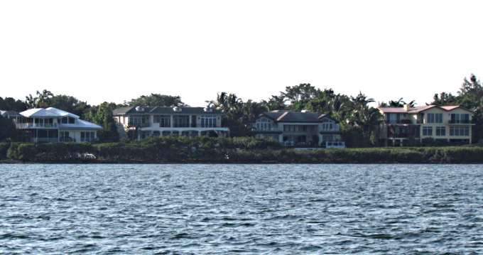
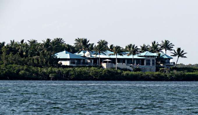
.... the cut was actually much wider than I thought it would be. There were homes along a lot of it on the south side, expensive homes. The day before I'd seen large private jets land and take off from a nearby airport on north Key Largo. No messing around and having to drive into Miami and take a commercial flights for some of these residents.
So I was motoring on after giving brief consideration to doing a 180 and waiting another hour. It was slow going but the cut is only about 1 3/4's of a mile long before you...
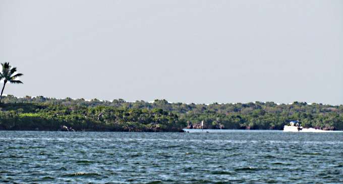
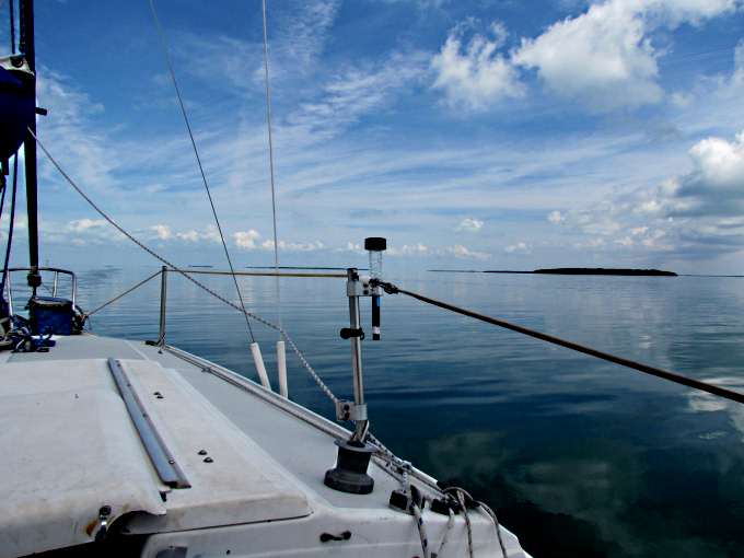
... exit on the Atlantic side. Above we are looking back at the Atlantic side from where I anchored about 1/3 mile south of the cut in open water that was about 8 ½ feet deep when I anchored but would go down to about 5 at low tide.
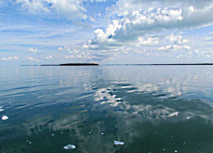
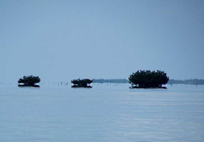
The channel from the cut actually goes out quite a ways after the cut proper until you get to the last channel markers shown above about ½ mile out. Notice how close they are together. You need to watch the channel all the way out to these, especially if you exit at low tide as there is very shallow water on either side of the twisty exit and channel out to the those markers.
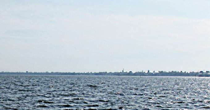
So here the boat and I were in the Atlantic. Actually for the second time as Ruth and I went a short ways into the Atlantic when we went into Boot Key Harbor at Marathon on our 2011 trip. Notice how flat it is above. I'll bet there are very few days in the year that you could anchor out here in these ideal conditions. I really lucked out here. The conditions remained into the night and the only time the boat really rolled around much was when boats use the cut and I'd get waked by them.
I was feeling good about being staged with no problems but also went to bed with some anxiety over what was ahead.........the Gulf Stream crossing.
=========================================================
...........................................................................................Next Page If There Is One...